
We were very surprised to find fry in the un-named tributary to Wildcat Creek recently. We have found, and positively identifiedCoho and Searun here in the past, but the rainfall has been very limited (still 1 inch below the 15 year lowest on record) and and we did not see any adults in the tributary this spring. We believe these are Searrun Cutthroat but can not confirm at this point. Of all the sallmonid species found in the park, they are the most reliant on open water year round, Sonetimes they never leave their natal stream.

Early by about 6 weeks! We are noticing orchids and saprophytes are popping out early this spring. We usu ally suggest looking for them during July. Also a new plant was added to our list of known species in Newberry we think is a Vvancouver Ground Cone. Commonly called a small ground cone. If it is Boschniakia hookeri, it is our first observation. It is definately a ground cone.

One of my favorites.

Stewards and Friends installed You Are Here signs provided by the Parks Department at several trail junctions in the park on Wednesday 14 January 2026. They were installed at locations where park patrons have become turned around for one reason or another.
")
")
Birdwatchers like to walk in groups so everyone has a chance to view birds before they take flight. In order to do this, they cant get too close to the birds as that would cause them to fly away. The Forest Management Plan for Newberry includes maintenance of two meadows (Bird Meadow and Birch Meadow). Stewards are in the process of removing invasives (Scotch Broom), planting ground cover and enhancing bird viewing opportunites in Bird Meadow.


The Pacific Crabapple is a small tree with a big role in the forest. It is found along wetland edges and can be up to 12 meters in height. The flowers are fragrant apple blossoms. There are sharp spurs along the branches. This years bumper crop has been discovered by the Stellars Jay, Robins and woodpeckers.

Each fall (Mid Late October) you should clean out your Mason Bee hotel, put the bees in a net bag for over wintering. These pollinators are not social, and parasites take advantage of an easy meal or host. The picture shows a group of maggots I found that are waiting for spring to hatch and attack the bees. Mites are also a problem and you should sanitize your hive with 1 table spoon of bleach to 1 gallon of water. If you are buying a hive, I highly recommend the LAMINATED type as they make cleaning easier and reduce loss of next years bees. Look up online how to clean your hive.
Houdini Fly maggots pictured below. Pollen mites can also overwhelm a hive.

A great work party with lots of help from around the county. Shout out to Aaron for getting us in on this and his support. We weeded, watered and fed all the Garry Oaks and with such great help were able to include a native plant walk before lunch.


Fresh coffee, muffins, snacks and good company

2 and 10 hour fuels were stacked along Deer Fern for chipping and it is none to soon. The woods are drier than normal for this time of year. All firebreaks were mowed this week with the exception of Old Timber, now that all the ground nesting birds have fledged. We are not preventing fires, we are just trying to reduce their intensity.

The Applesauce Gang continued work on Deer Fern trail removing Scotch Broom. A short section was used to establish an experiment relating to effectiveness of cutting versus pulling. Our preferred method is pulling and encouraging ground cover to prevent seed germination. They have expended a lot of energy in producing seeds and the literature states that cutting it is effective when the plants are in bloom. It has been our experience that cutting it does not work, and encourages coppicing making it even more difficult to remove. Bottom line is there is no wrong way to remove it, this is what we think works best for us!


The Applesauce Gang completed removing fast burning woody debris within 30 feet of Old Timber Parkway. By reducing these fuels we provide a defensible space for fire fighters and reduce the potential for ignition. Old Timber is the primary firebreak running east-west through the northwest corner of the park, as well as a popular hiking trail. We don't remove any live brush, as it's mitigation function is to shade the ground, increasing moisture retention in the soil, as well as providing cover and food for wildlife.

Michelle R recently set up a walk and talk in the woods with a professional wild land fire fighter. We were pleased to learn he appreciated our approach to protecting fire fighters, fire fighting equipment as well as the forest. Our newly gained knowledge led us to a break in the Scotch Broom franchise to remove and stack, for chipping, 2 and 10 hour fire fuels. The gang staged them for Kb Parks staff to chip along Old Timber Parkway. We will return next Wednesday to finish the west half of the parkway.


Congratulations to Michelle R. Tom C won Volunteer of the Year award for his many years as head cat herder for the stewardship group.
.jpg)
Wottaa mess. After one month of Wednesdays, the broom is finally off Ravens trail We prioritize removal of broom within 50ft of the trail for fire fuel reduction. We have had a lot of great help from friends and stewards. Thanks Bill, Eric, Michelle, Tim, Arno, Chris, David, Dawn, Joel and Frank.

Thanks to Aaron Bartleson for coordinating this great group of young men to help with our Scotch Broom invasion. 42 young men from The Washington Youth Academy worked a full day and cleared the area around Birch Meadow. Scotch Broom produces a biochemical agent (allelopathy) that prevents other plants from germinating near them. This area, in June, is usually filled with Tiger Lilies and Golden Trumpet Honeysuckle but over the past two years the broom has crowded them out. We hope to see some wildflowers here in late May early June. "At ease" men, Bravo Zulu
24 Enlisted men and junior officers from the USS Alabama put some teeth into the Applesauce Gangs bite. Our districts Natural Resource Manager, Aaron Bartleson, put this group together and we worked the Blue Hills Parkway from county road 25 down to the Garry Oak patch. One day this will be a majestic view while hiking to Belfair through the Green Mountain Forest.


The gang was spotted on Rhodie Hill attacking Scotch Broom this past Wednesday. We would like to welcome new gang members Grayson and Michelle to our Wednesday work parties.

It's a party anytime you get a chance to whack some Cytisus scoparius. We had a large group of KSS honor students working on Deer Fern Trail. The students were split into two groups, with one group starting on the north end and a second group worked from the south.


Old Loop Parkway is partially flooded during heavy rain events due to beaver plugging the 36 inch culvert near the Deer Fern and Old Loop junction . This culvert, Culvert 5, was replaced two years ago and the parkway elevated to reduce periodic flooding Beaver have moved into this area to forage during the winter months while their main food supply in the large pond gets a chance to recover. We will not clear the culvert until the open water hydroperiod has ended (Probably July or August). Please be patient and enjoy their antics.


Great group of helpers this morning made the final push prior to Saturdays plant. Bring on the trees.
 Curious Coyote cautiously watched me this morning. I got him to come closer by holding still and whistling.

Trees and browse protection have been purchased and staged for the fast approaching planting date! Chipping and trash removal will continue tomorrow and on the 18th of October.
Volunteers are on schedule to have the planting site ready by the 21st of October. Ladder fuels were removed from the east side of the meadow and a legacy dump site was cleared today.. Thanks to Dawn, Eric, Arno, Frank and David for helping today. More to follow.


Kitsap County Parks is currently developing uniform interactive maps for all its parks. The MAPRIKA app has been removed from this website as it is no longer available in the APPLE App Store. If you have the app, it should still work for now. We hope to have an official map soon, and will provide a link on our website for you when it becomes available.
Best work party in several years! Thanks to Kitsap Bank and all their volunteers. Several miles of Scotch Broom was removed along Old Loop Parkway and several vandalized signs were replaced. Aaron Bartleson led a chipping crew and reduced a lot of snow damaged limbs to chips on Old Loop and in Birch Meadow. Tom Coleman, Frank Stricklin, and Pat Stricklin led three Scotch Broom teams and Lori Raymaker made and installed the trail signs. Thank you to all our wonderful volunteers.
Great turnout of hard workers accompanied by great support from county parks chipped a lot of fire fuel on Saturday. The heavy wet snow crushed a lot of hardwoods in the park this past winter creating a fire hazard for the coming dry season. Friends and Stewards cleaned up the trails and stacked the broken branches along Old Loop over the past few weeks. We have one or two more days of chipping remaining, but it seemed like an impossible task until help arrived. Thanks! Aaron Bartleson and volunteers. 

A small but dedicated group of volunteers and stewards attacked Scotch Broom along Old Loop Parkway. Some came from as far away as Chile. Thank you Right to left: Julian (Exchange student), Nancy, Pat, Tom, Joel, KSS Honor Student Kaylee.
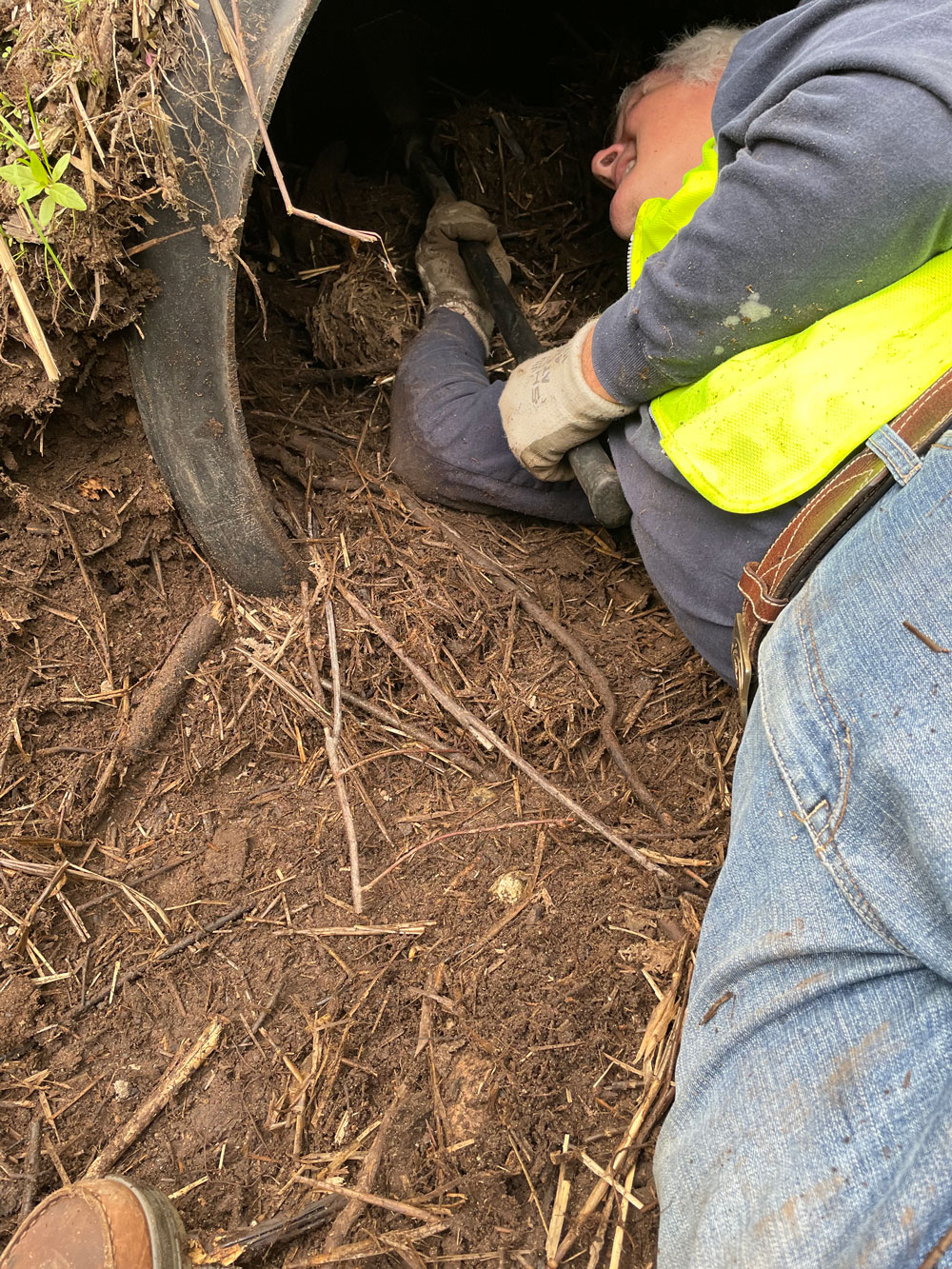
In order to comply with the Forests and Fish Law our 31 culverts are checked and cleared in late September before the rains arrive. We wait this long to allow standing water to be available for life forms requiring surface water. Culvert 5 was plugged by the beaver last winter, but the added road fill kept the water from flooding out the trail.
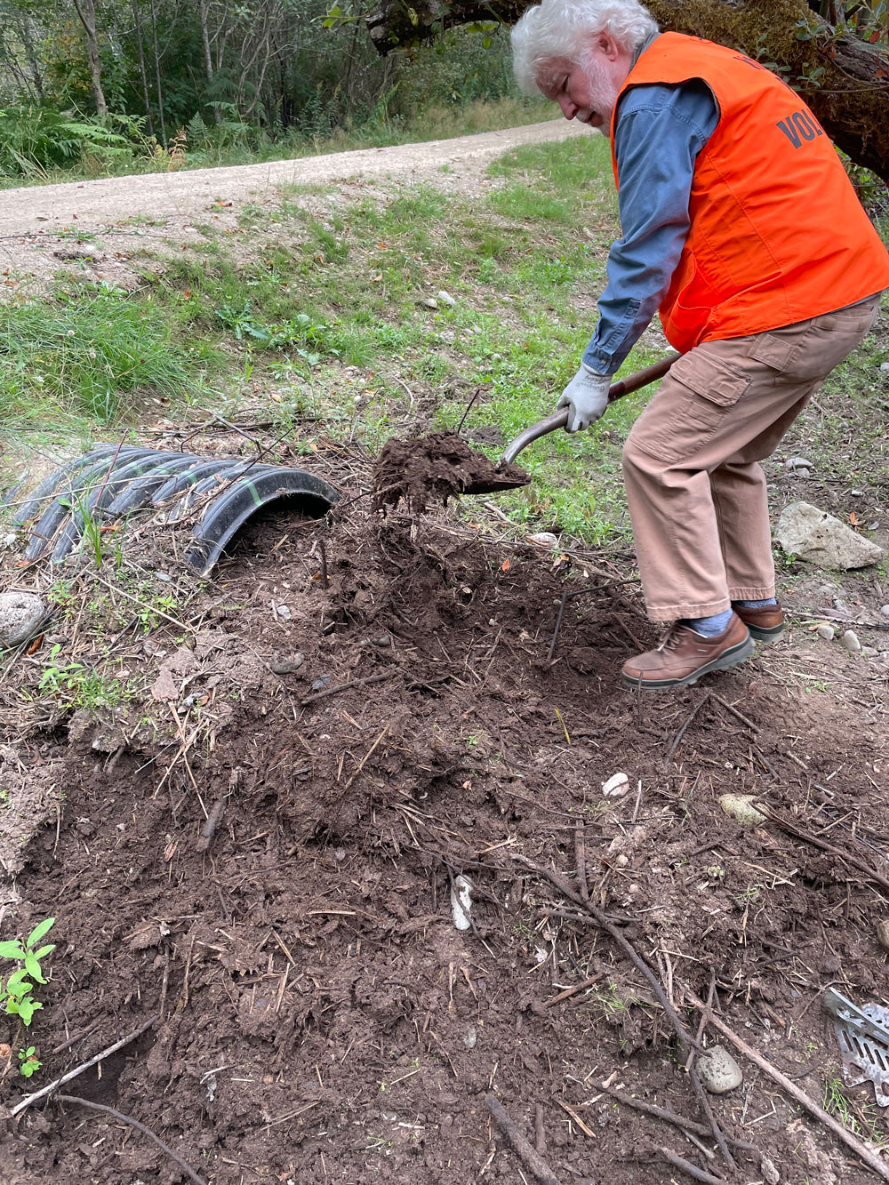
 It took several hours to remove debris from this 36 inch culvert.
